Monday, May 21, 2012

After the Trip

First off, the beauty of this island was nothing that pictures could prepare me for. The soils were not quite what I imagined, but even still it was gorgeous.

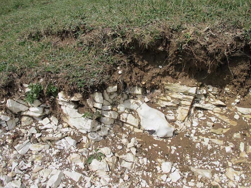
The Burrens had the best example of Ireland's Rendzina soils. The exposed limestone stretched on for what seemed like miles. There was ivy, orchids, and other natural flora all over the rocks. The plants grow in pits from erosion from wind or water.

 Here is a close up on a "pit" or groove into the rock with moved soil inside. The soil inside creates basically a pot for the plants to grow.


 In one of the stores we went to near The Burrens, they had a geological map hanging on the wall!
Even though it was from 1962, it was still very interesting to look at. 
544707_10150962174992495_636712494_11572416_880149686_n.jpg

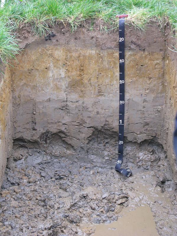
 The farming went over the mountains and almost to the top. The most weathered soil would be at the top, and probably would not make the best agricultural land.

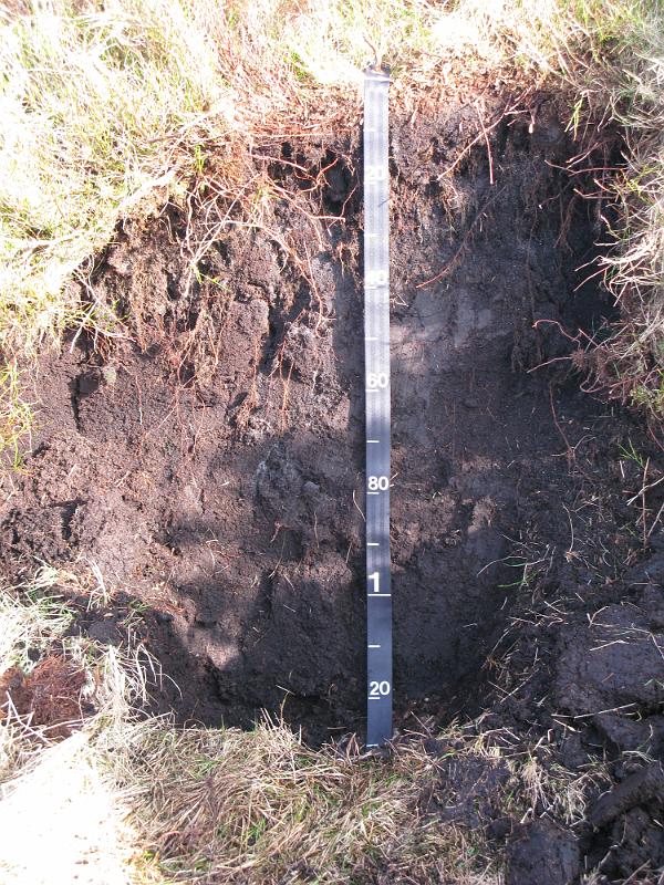
 This next picture is of erosion on some mountains on the Dingle Peninsula. Overall, I did not see too much of it on the larger mountain tops.

Though the soil was not red like Tara from Gone with the Wind, the beauty of the landscape is second to none. Even if you aren't interested in soil, the topography and landscapes of the  island are so worth the trip. 

Wednesday, May 2, 2012

Soils: Lithosols

These soils are the last major group present in Ireland. They are common throughout the world and go by many names. The FOA calls them Lithosols, but the USDA calls them Orthents. Their definition is highly weathered rocks with erosion issues.
In Ireland, they are mostly found in the high cliffs and mountainous regions, mostly to the west. They are very unsuited to anything agriculture, and have sparse plants and animals living in their ecosystem. They are extremely shallow and weathered. Most of the bed rock is exposed and shaped sharply.
Site 422
(http://soilcarbon.ucc.ie/)


Connemara National Park is located in the area classified as Lithosol soil. There has been a lot of erosion and natural earth phenomena, such as earth quakes and base rock shits that have shaped the face of the area. Their final shape was from the glaciers, which took most of the top soil out and gave the area the sharp, weathered appearance that it is known for.
References:

Soils: Rendzina Soils or Shallow Brown Earths


These soils are also known as Shallow Brown Earths, partially because of their color and shallowness.
Though not as common as the other types of soils covered so far, Rendzina soils have their own charm. They are typically poor for agriculture since they are very rocky and weathered. They are full of organic matter, but considered a very low soil in terms of development. They are closely associated with bedrock and have tend to have a lot of chalk in them. Apparently, they are so full of calcium if one were to take some acid and pour it onto the top soil, there would be a fizzing noise from the reaction.
Reference:
http://www.agresearch.teagasc.ie/johnstown/Soil%20maps/North%20Tipp/Book.pdf

Soils: Blanket Bogs

Like the Gley soils, Blanket bogs are another type of soil found in Ireland. However, they become water logged not so much because of the original composition of their soil, but because of the heavy rains and the topography of the area. They form in mountains or in low-lying areas with no water escapes. While they do have Sphagnum and peat mosses, they do not form the heavy, monoculture-like layers found in the Gley bogs. They have a very diverse ecosystem and are not as deep as some Gley bogs.
The Raised bog is more associated with Gley soils, while the blanket bogs have their own soil profile.
Heavy rainfall caused nutrients to be leached from the surface layers called paludification. As the heavy nutrients were washed further down, they became stuck and formed an iron pan. The water cannot penetrate this layer, and eventually the soil becomes water logged.
The soil has a huge nutrient reserve like the Gley soils; however they tend to have low pH (3.5-4.2). This low pH means more modification needs to be done to the soil before it is able to be used for agriculture. Many of these blanket bogs have already been drained and are used for farming or for grazing.
These bogs are also heavily conserved under the Republic of Ireland, it is estimated only 21% of the original blanket bogs are left, and they have mostly been turned into National Parks.
List of Blanket Bog National Parks:
Connemara National Park, Co. Galway
Glenveagh National Park, Co. Donegal
Killarney National Park, Co. Kerry
Mayo National Park, Co. Mayo
Wicklow National Park, Co. Wicklow


References:
http://www.ipcc.ie/bogsform.html
http://www.ipcc.ie/infoblanketbogfs.html

Soils: Gley Soils

One of the more common and icon soils of Ireland is the gley, which is more commonly known as bogs. The soil has a large clay composition which aids in its inability to drain.  This inability for soil to drain leads to eventual oxygen depleted zones which preserves anything in that area. With no oxygen, microbes cannot consume fallen plant, or even animal matter, which can be used later in many ways.
The soil is actually deep, the plants have built up over a large amount of time and every year more is accumulated on the top levels.
These iconic soils have a large part in the history of Ireland. Since there are no large forests, the plant life from the bogs are used for everything from housing to fuel to horticultural practices. In most of the bogs, the main plant life is Peat. There is a company in Ireland that does the majority of the harvesting and maintenance of the commercial bogs; Bord na Móna. They harvest the peat for everything from electricity, fire logs, to fertilizer.
When the peat is totally used up, which can happen from heavy removal, the land may be turned over for farming. This soil underneath the heavy layers of peat is quite nutritious and can be highly sought after. Since the peat tends to grow on top of each other, the nutrients at the bottom and in the soil are still available for new plants if the bog is drained of its peat.
 
There are many examples of both gleys with the bog still intact verses a gley that has already been used for agriculture. The soil on the left is without conventional agricultural practices and the one on the right has been used for agriculture.

References:
http://www.soil-net.com/album/Soils_Rocks/slides/Irish%20Gley%20soil%20profile.html

http://www.askaboutireland.ie/reading-room/environment-geography/environmental-information/biodiversity/definitions/soils-in-ireland/